|
|
|
|
|
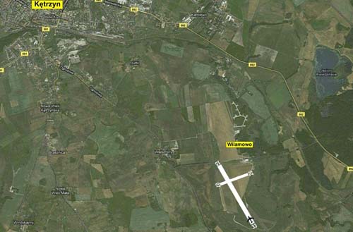
Foreground description:
The airport is situated on a plateau, surrounded by numerous fields.
There are no significant high obstructions.
|


|
Airport description
1. Main runway
 |
Dimensions: length: 1105 m, width: 80 m
|
 |
Daytime runway markings:
white stops placed every 200 m
white flags every 50 m
|
 |
Nighttime runway markings: portable eletrical lanterns
|
 |
Runway touchdown zone markings:
Daytime: Letter 'T' on request or red flags for training and starting flights |
 |
Nighttime: Letter 'T' - white light illumination
|
 |
Landing approach direction: 150° - 330° |
 |
Type of surface: grass |

 |
Daytime VFR flights in conditions not worse than:
- cloud base: 150 m
- visibility: 1,5 km |
 |
Nighttime VFR flights in conditions not worse than:
- cloud base: 500 m
- visibility: 5 km |
 |
Circle direction:
at the aircraft commander's discretion or, if the AFIS service is on duty,
according to the flight chief controller's instructions |
 |
Emergency landing area:
Nearby farming fields |
Determining flight orientation:
Local limitations: none

EPKE - AIP VFR 
|
|
|
|
|
|
|
|
|
|
|
|
|
|
Air show "Mazury Airshow" are a continuation of several years of very good performance and positive experiences Masuria Picnics Aviation. The aim of the event - the air show, organized over the Niegocin lake in Gizycko is to present a beautiful spectacle for tens of thousands of observers gathered at the public beach, in the port of Masuria ships and other vessels and also around the lake. The only event of this type is implemented as an initiative to "non profit" and access for all observers is free of charge. The show "Mazury Airshow" always involved top acrobatic pilots teams and seaplanes, and great individual acrobatics , domestic and foreign.
Concomitant of "Mazury Airshow" are always promotion flights over Masuria region and a very impressive aircraft exhibition at the Wilamowo airport.
|
|
|
The Great Masurian Lakes AeroClub since 1999 carry out the management
functions of the airfield Kętrzyn Wilamowo and organizer of numerous
aviation events - national and international. The most important and
unique event is "Mazury Airshow". More in CALENDAR OF EVENTS. AKJ
awarded an honorary award "BLUE WINGS" by the National Board of
Aviation, twice (in 2008 and 2011) certificate: "TOURIST PRODUCT OF THE
YEART", a prestigious statuette: "BEST PRODUCT AND SERVICE OF WARMIA AND
MAZURY". In 2009, the Minister of Sport and Tourism honored AKJ Badge of
Honor "FOR SERVICES TO TOURISM." As part of internet plebiscite "Eagles
Aviation 2011" AKJ obtained the title EAGLE AVIATION in the category:
Promoter of the Year 2011. Since November 2009, AKJ office is located in
Gizycko.
|
|
|
The "FlyTour" is an initiative to prepare a team of people and offers
to support crews in the aviation tourism at airports in Poland, rallying
at the Polish and international airports and foreign flights reported.
The team of "FlyTour" is to be an effective partner of pilots and
aviation flight organizers in securing all matters arising from the
logistics needs of the maintenance of aircraft and their crews
traveling. Fuel affairs, security, aircraft parking (ramp and hangar),
hotels, guides, Rent a Car, communication within the airport, a special
(individual) trip program for a period of residence but also other
needs of the individual wishes are and always will be our domain
coordinator of the "FlyTour".
Contact us at mail: wilamowo@lotniskoketrzyn.pl
flytour@lotniskoketrzyn.pl or, alternatively tel/fax: +48897524521 or
+48503172835. We provide advice and assistance, and always and in all
cases, we are at your disposal.
|
|
|
Foundation "Military Park" created by Stanislaw Tołwiński which is the initiator and consistently creating at the Airport Ketrzyn Wilamowo (Hitler's former super-secret military airfield) Educational and Historical Complex aimed at promoting the army and popularizing defense, collecting and displaying combat military equipment and several initiatives to organize defense - great for fans of military science. The most important events of the Foundation - open to numerous public and implemented at the airport Ketrzyn Wilamowo - a Military Picnic, Junior Shooting Tournament and Masuria Technical and Defensive Maneuvers - supported by measures the Ministry of Defence.
|
|
|
In the year 2008 for organization of aviation events, The Aeroclub of the Land of Lakes was given a reward for "The Best Product and Service of Varmia and Mazuria.The prestigious prize is awarded annually in a competition organized by the Office of the Marshal of Varmia and Mazury,in cooperation with the editorial staff of "Olsztyn Gazette","Journal of Elblag"and the "Polish Radio Olsztyn".The criteria taken into account in its award are: service quality, compliance with the expectations of customer service, innovation, competitiveness, public opinion, additional services and the promotion of the region through service.
|
|


|